Where should we prepare?
Static danger indices do not show every local consequence. Municipalities and landowners need to identify priority areas, exposure and feasible preventive work.

Explore the evidence, changing climate, exposure and the local decisions at stake.
Fire services and planners must make decisions across changing weather, terrain, vegetation, communities and infrastructure. Relevant data exists, but often sits in separate systems.
Climate change can increase fire-weather extremes. European assessments project that new wildfire-prone regions may emerge in western, central and northern Europe. Norway’s 2018 drought and heat showed how quickly a severe season can strain local capacity. Risk is expanding into northern latitudes, while local fire counts remain variable.
Sources: Copernicus, European State of the Climate 2025; Rafaqat et al., Scientific Reports (2025).
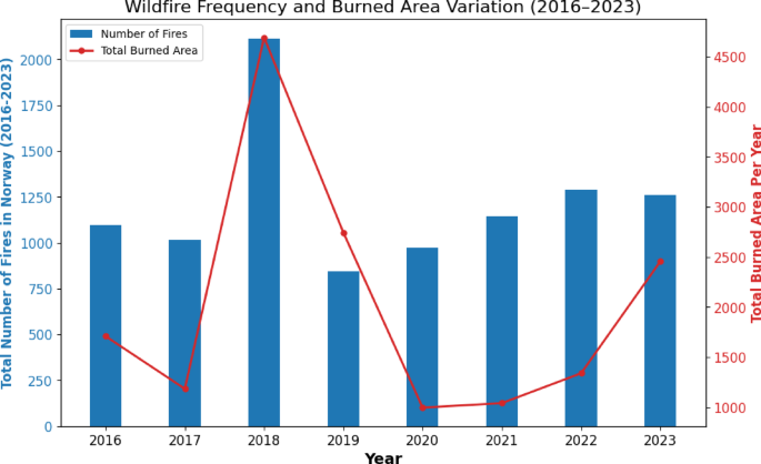
Increase in forest and grassland fires compared with 2017, as reported in the study.
Estimated additional spending associated with the 2018 increase.
Average in the cited 2018 estimate. This is not the cost of every wildfire response.
The eight-year Norway dataset documents annual variation and an exceptional 2018 season; it is too short to establish a long-term climate trend in Norwegian fire counts by itself. Wider European projections address the changing geographic risk.
Static danger indices do not show every local consequence. Municipalities and landowners need to identify priority areas, exposure and feasible preventive work.
Responders need a location-specific view of possible fire development, when assets may be affected and where resources could be positioned.
Incidents, field observations and the effect of preparedness actions need to feed back into future plans and model improvements.